Web VTS is a highly sophisticated web-based
marine traffic monitoring system for ports and other organizations interested in
monitoring real-time or historical vessel traffic.
WebVTS designed for vessel traffic and monitoring centers
and increases the safety, security and efficiency of operations
within a port.
WebVTS provides a complete AIS interface that
includes the ability to:
- View and track all AIS equipped vessels
- Display specific vessel information
WebVTS assists port authorities and other traffic monitoring operators to:
- Identify and track AIS equipped vessels
- Provide additional information to assist collision
avoidance and investigation
- View archived/historical data
- Make any operational decision or action
- Provide full range of unique marine traffic reports
WebVTSs interface and display of AIS
related information offers port operators a substantial leap
forward in their ability to communicate and interact with
vessels. Since WebVTS is fully configurable,
operators can adjust the size of the chart panel, customize
color patterns for AIS targets, set alarms, create reports,
filters, and zones specific to each user.
WebVTS is a unique tool to see your vessels from anywhere. The
web-based architecture or WebVTS allows you to always see where your vessels are.
And even if you are out of the office, you are in touch with your ships.
A computer with an internet connection is all what is required.
WebVTS receives AIS data from our AIS Server stations and provides a
graphic display of AIS targets onto electronic charts and maps.
WebVTS supports Google maps, Microsoft Virtual Earth maps,
Microsoft MapPoint maps, and BSB nautical charts.

WebVTS with Microsoft Virtual Earth maps (click on image to enlarge).

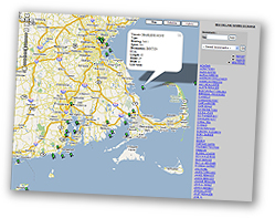
WebVTS with Google maps (click on image to enlarge).

WebVTS with BSB nautical charts (click on image to enlarge).

WebVTS with Microsoft MapPoint maps (click on image to enlarge).
WebVTS produces a full range of unique marine traffic reports

Example of Arrival/Departure report (click on image to
enlarge).

Example of Speed Violation report (click on image to
enlarge).

Example of Berth Time Summary report (click on image to
enlarge).
Product highlights:
- Supports Virtual Earth, Google, MapPoint maps, and BSB nautical charts
- Displays unlimited number of AIS equipped vessels
- Supports different types of AIS transponders (Base
Stations, Class A, Class B, Aids to Navigation, and Airborne)
- Report Designer and customizable reports
- Zone Designer and user defined zones
- Filter Designer and user defined filters
- Exceptional alarm options
- Email and SMS alarm notifications
- Unlimited historical data and History Replay function
- Search Vessel function (by MMSI number, name or call
sign)
- Full navigational chart functionalities such as
zooming and panning
- "Tracking" of a specific vessel


 Maritime Information Systems (MIS) has been providing the maritime industry with comprehensive, state-of-the-art information through a powerful suite of online tools.


